Climate in-brief

  • Models divided on the June outlook following handy falls through NSW and eastern Qld in the last few days.

  • The remainder of June is shaping up as more in line with climatology (average rain/temp statistics) despite the BOMs access model showing an emphatic wet signal across large areas for the second fortnight in a row.

  • A look back on the international seasonal model guidance against Autumn precip and temp observations found accuracy with a general wet theme for Australia, however none of the models surveyed captured the conditions accurately across the forecast area.

The chart above shows the intense high pressure over Australia easing in the last 7-days with more normal air pressure. Encouraging to see low air pressure in the eastern Indian Ocean as the dipole commences its life cycle for 2021.

The chart above shows the intense high pressure over Australia easing in the last 7-days with more normal air pressure. Encouraging to see low air pressure in the eastern Indian Ocean as the dipole commences its life cycle for 2021.

Australian daily and weekly rainfall observations

Localised falls of ~50mm in the last 48 hrs through eastern parts. tp://www.bom.gov.au/australia/flood/?ref=ftr

Localised falls of ~50mm in the last 48 hrs through eastern parts. tp://www.bom.gov.au/australia/flood/?ref=ftr

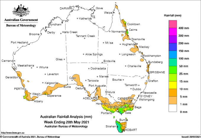
Weekly rain has favoured the Murray-Darling Basin. Note the falls from the 24hrs (left) have not been included in this chart yet.Australian 7-day rainfall map courtesy http://www.bom.gov.au/climate/maps/rainfall/?variable=rainfall&map=totals&period=week&region=nat&year=2020&month=12&day=17

Weekly rain has favoured the Murray-Darling Basin. Note the falls from the 24hrs (left) have not been included in this chart yet.

Australian 7-day rainfall map courtesy http://www.bom.gov.au/climate/maps/rainfall/?variable=rainfall&map=totals&period=week&region=nat&year=2020&month=12&day=17
Analysis: Mar-May season predictions v observations

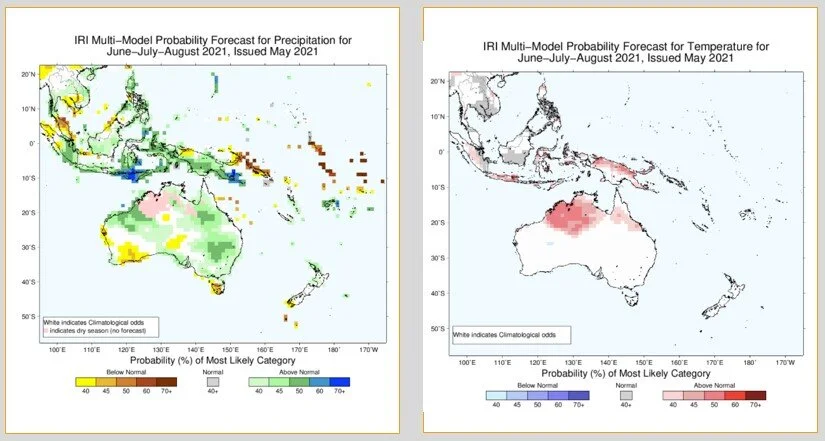
A look back to mid-February 2021 at the seasonal forecast issued for Mar-May showed a wet signal virtually split between three model sources between southern, central and northern parts of eastern Australia. The observations for that period (top chart, below) shows a reasonable representation of the models over the period with a few exceptions: the Vic Mallee was hammered with decile 1-3, not picked up and Eastern Qld was on the leaner end of rainfall. The CMCC European model probably did the best of the three and also picked up the central-Australian rainfall extending across from moisture off the WA coast. No clear winner this Autumn among any of the temp or rainfall predictions, again validates the difficulty during this time of year.

Slide2.JPG
models end feb.jpg

Multi-week planner (8-28 days)

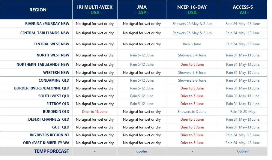
The latest global cloud (OLR) predictions show heavy cloud crossing the Australian continent from 16-22 June - which seems to have the BOMs access model very excited for June (bottom figure). However, none of the other models are having a bar of it. There is no strong tropical influences or other active remote drivers behind the increased cloud cover bringing moisture, so caution required on this bullish wet forecast currently making air waves. The best chance for rainfall seems to be during weeks 2-3 of June, but no big amounts predicted, and more in line with median totals for the month.

Model commentary: Another day at the track with bookmakers salivating at the erratic form shown in the field of runners to date. The mid-field cluster seems to be centred around the IRI and JMA models playing it safe on the rails over the distance. The sprinter over the mile, NCEP, is still showing little excitement and reason to be popping corks through the latest campaign. The main talk in the betting ring is the poor form of stallion ACCESS-S, which could well come back as a gelding next week unless it can show the punters why they should remain loyal and optimistic.

Go to 10-day Forecast XL for a full summary of all ‘weather models’ as rain events draw closer for your area: https://meteologix.com/au

BOM June.jpg

Monitoring the SAM

Now we are in winter its time to start monitoring the SAM again. When the SAM is negative, winds from Antarctica blow further north up into southern Australia. When the SAM is positive, these winds pull back towards Antarctica, allowing moisture from the tropics to push into Qld and NSW. The SAMs main influence is in spring and summer, but it is worth keeping an eye on to help us ground truth model guidance when we see a change. A really good video at the bottom of this article will help explain this a little better.

The latest values show the SAM around neutral and moving into positive phase (red arrows) which you would anticipate circulating moisture into central eastern areas, although the SAMs impact is only weak during early winter.

Antarctic Oscillation or SAM values (4 June)

Recent research by Hendon et al, (2014) at the Centre for Australian Weather and Climate Research found the Southern Annular Mode to be the leading mode of circulation variability through parts of inland eastern Australia where cotton is grown; particularly in the spring planting period.
 
A positive SAM has been proven to increase moisture supply into fronts and troughs forming in eastern Australia. The chart provided by Climate Prediction Center (US) shows the most recent observations of the SAM or (AAO). 

A negative SAM traditionally leads to a dry westerly circulation pattern through eastern Australian cropping areas.
 
BOM researchers Lim and Hendon (2013) found the SAM has the strongest connection with El-Niño Southern Oscillation in October and November – whereby the SAM is influenced most by El Niño or La Niña conditions.

Growers and advisors are encouraged to monitor the phases of the SAM together with seasonal forecasting, multi-week and short term weather models during planting. A short cartoon explaining the SAM can be found HERE

Monitoring soil moisture this winter cropping season

A glance at the root zone moisture from the BOMs water balance model (24hr rain not updated yet) shows soil moisture improving through SE areas that were very dry. The other main feature is the dryness in central and eastern Qld that never really got a dose of La Nina. If the BOMs latest June forecast is on, then this could look completely different in a fortnight.

Source: http://www.bom.gov.au/water/landscape/#/sm/Relative/day/-28.4/130.4/3/Point////2021/6/3/

Rootzone soil moisture 3 June

soil moisture.jpg

10-day rainfall outlook

Today’s 10-day ECMWF model loop shows most of the action in NSW and a system developing across central eastern Qld areas (later in the loop) that have been missing out. Could be an interesting month with quite a range of scenarios among models for the month of June. Weather models are much better at picking up rain-bearing systems originating from the east, as multi-week and seasonal models seem to struggle to accurately simulate these smaller, intense events.

Keep an eye on https://meteologix.com/au for more site-specific analysis.

Image loop courtesy Meteologix

Image loop courtesy Meteologix


Meet the photographer - Jordan Cantelo

Jordan_Selfie_Roebuck Plains.jpg

Jordan Cantelo

Landscape Photographer, Western Australia

Climate enthusiasts are not limited to farmers, graziers and commodity analysis. In fact, weather and landscape photography require their own unique understanding of climate science and degree of weather literacy. Planning, travelling and capturing images can be laden with risk and their own distinctive set of challenges.

Farmer Forecast caught up with West Australian photographer, artist and firefighter Jordan Cantelo about his foray into loving the landscape, climate and adventures capturing stunning images of weather in the outback. Jordan exudes enthusiasm and energy for his passion for nature and the outback, with a kind message for all of our farmers at the end of this interview.

What inspired you to become a landscape photographer and at what age was this?

My love of photography started when I was fortunate enough to travel overseas when I was 15yrs old. The opportunity to see some amazing scenery in the French Alps and then capture that with my point and shoot camera - then see it in print was awesome.

It was a few years later that I eventually purchased a DSLR. My job had me travelling right around the state and I wanted to capture the amazing landscape Western Australia had to offer, it is then that my love of photography really took off.

I would make note of the places I visited during my work trips, then head back during holidays and bring the camera with me to capture it. We are so lucky to live in such an amazing corner of the world and being able to capture moments and then print them is very rewarding.  

Do you have any extended family or other connections in the outback or with agriculture more generally?

No extended family in the outback or with agriculture, however, we have family friends who own a dairy farm in the South West near Busselton. I do regularly bump into farmers when I am photographing out in the Wheatbelt.

Wyalkatchem Wheatbelt, WA

Wyalkatchem Wheatbelt, WA

Jordan and wife.png


What are your favourite activities or interests away from photography that help recharge you for work mode?  (e.g. sports, cultural, family, music etc.)

Certainly family time. I use to play in the local football team and had a few years off, then joined another team when I moved to the country, however, a quick run with injuries during the pre-season put an end to that short revival.  My normal day to day job is extremely busy during the Autumn, Summer and Spring times with extended time away from home, so my relaxing time away from photography includes spending as much time as I can with my wife and my two sons.

 
Dandaregan wheatbelt, WA

Dandaregan wheatbelt, WA

DALWALLINU MIDWEST, WA

DALWALLINU MIDWEST, WA

ARIANO MIDWEST, WA

ARIANO MIDWEST, WA

DOWERIN WHEATBELT, WA

DOWERIN WHEATBELT, WA


Do you follow climate influences to help better understand opportunities for weather events? I.e. El Niño-Southern Oscillation phases impacting cyclone frequency or wet seasons?

I watch out for ENSO for a curiosity factor but living in Western Australia I tend to follow the Indian Ocean Dipole more so, even though there is a link the IOD has with ENSO events. I do tend to watch out for these climate factors planning my big photography trips to the Kimberley. A forecasted good wet season can sometimes mean a very active build up in the top end. If the forecasted phase is not looking so promising and a drier season is forecast, then this tends to affect when and where I travel to, or if I go at all.

Where do you go or what sites do you visit to keep up with weather and climate info?

I use a couple of websites mainly for weather information. For climate information, I tend to use the official Australian Bureau of Meteorology website (http://www.bom.gov.au) and for my day to day weather, and while photographing storms I use the BOM website, as well as Weatherzone (http://www.weatherzone.com.au).

Phases of the Madden-Julian Oscillation impacts weather during the monsoon – do you track the MJO prior to going out and travelling?

I tend to track the MJO when I am around the Pilbara and Kimberley regions while on my photography trips. When the MJO is in the region, the chance of cyclones, and heavy rain will determine where I can and cannot go.

When the MJO is forecast to be in the region, I will watch for enhanced rainfall especially when I am in the eastern Kimberley. It is a 10-11hr drive from Broome to Kununurra, and when it floods out that way, you can get stuck quickly.

So yes, I do watch the MJO prior to travelling into the Kimberley.

Wyalkatchem Wheatbelt, WA

Wyalkatchem Wheatbelt, WA

kellerberrin wheatbelt, W.a

kellerberrin wheatbelt, W.a

Storm chasing and thundercloud photography is a speciality of yours. Have you had any near misses or ever been caught or bogged in a severe storm?

Storm photography is inherently dangerous. To capture the images I am looking for, I tend to set myself up in some precarious positions. It requires a bit of planning, knowing your roads, knowing the limits, and knowing when to turn around. I think this has saved me on a few occasions, especially when heavy rain affects unsealed roads and flash floods that make roads impassable.  I have had a few close calls with lightning, heavy rain and hail; however, one time stands out. Recently I was in the Pilbara with my brother near Karijini National Park. We were photographing a series of storm cells that had developed during the heat of the day. The clouds were extremely dark with big downpours of rain coming down in sheets. The lightning was not extremely active, with most lightning embedded in the rain. While we were setting up, out of what seemed to be nowhere, a lightning bolt landed not too far behind us. The crack of thunder was almost instantaneous, so the strike was extremely close. We believe it was on the hill that was directly behind where we were setting up (no more than 150-200m away). Lightning can strike up to 20km away from the centre of a thunderstorm, so if you are within that 20km, you are in the strike zone. While you must be extremely unfortunate for that to occur, it does sometimes occur, and people have been caught out on many occasions.

Where are your favourite areas for weather photography that still make you excited to visit, or you feel completely at peace when in that spot?

Anywhere in Western Australia is special. From the dramatic ancient landscapes of the Pilbara to the Tropical Savannah of the Kimberley, to the crashing big swell southwest coasts and to the flat and equally amazing farming country of the Wheatbelt, there is something to see all the time. Watching these huge thunderstorms form 20,30,40 thousand feet into the air from what was blue skies only an hour earlier is mind-blowing. While I really do love watching these cells blow up into the skies, I do prefer for them to be in area’s that are extremely remote and away from farmlands.

A message to our farmers from Jordan:

I thoroughly appreciate and hugely admire the work that every farmer does in getting a crop ready for harvest, and that I understand that my photography sometimes will capture severe storm activity that may affect the livelihood of others who have put blood, sweat, tears and many thousands of hours of work in to get a crop ready to harvest.  

The unfortunate side story to being out and photographing these storms is that sometimes these severe storms bring heavy rain, severe winds, and large hail to the area’s that they form. These storms can have a devastating effect on farms in the line of fire and on occasions. I have seen hail and lightning cause a terrible amount of damage to crops that are ready for harvest.  The work that the farmers do to get the harvest off in a timely manner is extraordinary. It’s not uncommon for me to be out at all hours of the night during harvest time watching the weather and on the horizon, there are the high beam lights of farming equipment going back and forth getting the crop off.

I can only appreciate from the outside looking in, that the stresses that these storms can bring during these periods.

 
Gibb river rd, Kimberleys WA

Gibb river rd, Kimberleys WA


Want to see more of Jordan’s sensational photography? You can find his work at www.jordancantelo.com

Any questions, feedback for Jordan or Farmer Forecast?

Email us at: farmerforecast@agecon.com.au

2021 Long-range driver update

  • The latest global model summary released by the BOM this week shows a neutral ENSO favoured during the business end of the winter crop and spring pasture growing conditions - although it is trending wetter as the year progresses.

  • The Indian Ocean Dipole outlook is again erratic, after almost settling a fortnight ago. What the bar charts don’t show is the warm sea temps around Australia’s northwest coming through the models increased chance of NW cloud bands for eastern Australia.

  • The ENSO Modoki is trending wet (black line, below). The JAMSTEC forecast is down, although the scientist there emailed through the numbers and is not quite as optimistic as the BOMs outlook.

  • Modoki and warm ocean temps around Australia are flowing through model predictions as wetter than normal conditions, despite neutral IOD and ENSO.

The chart above shows neutral ENSO conditions likely, but trending towards a late La Nina againhttp://www.bom.gov.au/climate/enso/#tabs=Pacific-Ocean

The chart above shows neutral ENSO conditions likely, but trending towards a late La Nina again

http://www.bom.gov.au/climate/enso/#tabs=Pacific-Ocean

The BOM’s ACCESS-S model shows this indicator moving more into wet phase than a fortnight ago. A good thing for eastern Australia.

The BOM’s ACCESS-S model shows this indicator moving more into wet phase than a fortnight ago. A good thing for eastern Australia.

Indian Ocean Dipole outlook (25 May)

This looked settled a fortnight ago, but the passing MJO played havoc with SSTs in the Indian Ocean! All over the place again, but we have warm water outside this measuring zone - which is a good thing.Forecast chart courtesy:http://www.bom.gov.au/c…

This looked settled a fortnight ago, but the passing MJO played havoc with SSTs in the Indian Ocean! All over the place again, but we have warm water outside this measuring zone - which is a good thing.

Forecast chart courtesy:http://www.bom.gov.au/climate/enso/#tabs=Indian-Ocean

What affects me, when? A rolling 3 month moving window: See here, EMI = Modoki (navy), Nino3 = ENSO (green), IOD = Indian Ocean Dipole (red) and SAM = Southern Annular Mode (yellow). White - not significant!From Lim et al (2012): https://www.cawcr.gov.au/technical-reports/CTR_051.pdf

What affects me, when? A rolling 3 month moving window: See here, EMI = Modoki (navy), Nino3 = ENSO (green), IOD = Indian Ocean Dipole (red) and SAM = Southern Annular Mode (yellow). White - not significant!

From Lim et al (2012): https://www.cawcr.gov.au/technical-reports/CTR_051.pdf

10-day rainfall outlook

Today’s 10-day ECMWF model loop shows most of the action in the west, with some light falls in eastern states at the end of the forecast loop. A quick look at the refreshed JMA model (IRI not updated) sees this pattern continuing and moisture moving across to central Australian areas, not quite making it to NSW and Qld now until the second half of June.

Keep an eye on https://meteologix.com/au for more site-specific analysis.

Image loop courtesy Meteologix

Image loop courtesy Meteologix


Climate in-brief

  • The MJO is set to have little influence over Australia, as it is predicted to weaken as it enters the Maritime continent region to the north of Australia.

  • The remainder of May looks dry for much of the northern tropics, Qld and NSW. A weak rain-bearing system is more likely in weeks 1-2 of June, although the strength of the system is unconvincing at this stage.

  • A check on international seasonal model guidance for the winter season favours mid-tercile (average) precipitation and temperatures. Some encouragement for the spring season as a wet phase Modoki and Indian Ocean develop.

The chart above shows very little change from last fortnight. The low off NSW has since moved away and the high pressure ridge has intensified.

The chart above shows very little change from last fortnight. The low off NSW has since moved away and the high pressure ridge has intensified.

Australian daily and weekly rainfall observations

Very little rain in the 24hrs to 9am.http://www.bom.gov.au/australia/flood/?ref=ftr

Very little rain in the 24hrs to 9am.

http://www.bom.gov.au/australia/flood/?ref=ftr

Weekly rain symptomatic of the intense high-pressure system over Australia (above).Australian 7-day rainfall map courtesy http://www.bom.gov.au/climate/maps/rainfall/?variable=rainfall&map=totals&period=week&region=nat&year=2020&month=12&day=17

Weekly rain symptomatic of the intense high-pressure system over Australia (above).

Australian 7-day rainfall map courtesy http://www.bom.gov.au/climate/maps/rainfall/?variable=rainfall&map=totals&period=week&region=nat&year=2020&month=12&day=17

Multi-week planner (8-28 days)

Every now and then we are reminded why this ensemble is useful for multi-week planning with a cross-section survey of models. The latest BOM multi-week guidance would suggest a flood for central Australia (see map added below), however, other international models have taken a very different view. For those still harvesting/picking summer crop or weaning calves etc., it looks like more of the same: fine weather until the 1st week in June when a weak change is developing. The foreseeable event early in June is tending to favour N NSW and S Qld areas, making this event pretty tricky to predict, as models don’t do easterly influences that well. The BOMs ACCESS S model has shown us that it gets way too excited by the Indian Ocean or MJO wet signals and this looks like one of those occasions.

Multiweek models.jpg

Model commentary: A fair spread on the field this week with the IRI and JMA sitting midfield and jockeys content to sit on the rails and not set the pace over the distance. On the other hand, the stewards look set to investigate ACCESS-S after streaking to the front in a show of exuberance, only to then shy at a pink dress in the crowd near the winning post and spear the jockey. NCEP is more comfortable at the tail of the field, more cautious than most, although has good form nonetheless over the shorter distance.

Go to 10-day Forecast XL for a full summary of all ‘weather models’ as rain events draw closer for your area: https://meteologix.com/au

BOMs outlook.jpg

2021 winter seasonal outlook

A survey of 12 international models condensed in the below charts (top both and bottom LHS) shows the outlook for winter rain sitting in the mid-tercile range for the BOM and other EU multi-system, whereas the IRI North American ensemble is more bullish on higher precipitation. Temperature predictions (bottom RHS) show a similar theme with no signal for cooler or warmer conditions. This is not unusual given most indicators are quite close to neutral. The longer-range charts do favour a wet Indian Ocean Dipole developing along with a wet Modoki phase, influencing our spring. SST predictions also favour warm waters through the Arafura Sea and Ningaloo Reef which could well be flowing through model outputs for the mid-latitudes.

See bottom chart for the IRIs refreshed early spring outlook!

Order of Figures clockwise from top left: ACCESS-S tercile forecast, CS3 multi-model tercile (ECMWF, UK, France, Italy, US, Japan), 5x North American models combined on the bottom showing rainfall (LHS) and temperature (RHS). IRIs extended outlook at the bottom.

IRIs winter precip and temp forecasts

IRIs winter precip and temp forecasts

IRI’s early spring forecast refreshed this week.

IRI’s early spring forecast refreshed this week.

Monitoring the MJO this Autumn

The chart below shows the MJO currently in Phase 3 in the Eastern Indian Ocean, then moving quickly towards the Maritime Continent north of Australia in Phase 4 then disappearing into the circle (weakening). Each global model has a different take on the behaviour of the MJO as it reaches Indonesia. Most of the action appears to be along the equator and further north through this weak and erratic MJO event.

The Madden – Julian Oscillation (MJO) is a tropical disturbance that moves eastward around the global tropics every 30-60 days and has proven to influence rainfall and temperature conditions. The strength of the MJO may increase or decrease as it progresses eastwards, affecting the level of convection and influence on both precipitation and temperature. The diagram below is used by scientists to track the path of the MJO showing predicted dates through various phases (see December MJO explainer). A short YouTube cartoon explaining the MJO can be found here

Monitoring soil moisture this winter cropping season

A glance at the root zone moisture from the Federal Governments drought map shows most cropping areas pretty well off, with the exception of Vic and SA areas. Much of Australias central-northern pastoral zone is still dry. The big mover in the last month has been SE Qld and the Darling Downs region, now with above-average soil moisture.

Source: https://map.drought.gov.au/

Rootzone soil moisture 21 May

root zone moisture.jpg

Global tropical hazards

(from U.S Climate Prediction Center)

NCEP TC watch is showing very little going on in the Australian region out to 26 May. This time of year the MJOs impact tends to be more Northern Hemisphere-based, as shown by heavy rainfall around and north of the equator. Dry weather across the Western Indian Ocean shows the MJO has moved eastwards at least. With the monsoon and MJO losing its influence on rainfall, this TC Hazards section will go to the sidelines next week.

Is there anything in this MJO event?

The chart below shows a weak pulse of the MJO in Phase 3 coming towards Australia (Phases 4-6) and the Maritime Continent. The Phase index shows a weakening (inside the circle) and the possibility of the MJO re-strengthening (green line) moving outside the circle. However, cloudiness and moisture are still set to arrive at the end of May and the start of June - bottom charts, red arrows (MJO analysis courtesy NOAA). In particular, cloudiness seems concentrated over the eastern Australian mid-latitudes.

The Madden – Julian Oscillation (MJO) is a tropical disturbance that moves eastward around the global tropics every 30-60 days and has proven to influence rainfall and temperature conditions. The strength of the MJO may increase or decrease as it progresses eastwards, affecting the level of convection and influence both precipitation and temperature. The diagram below is used by scientists to track the path of the MJO showing predicted dates through various phases (see December MJO explainer). A short YouTube cartoon explaining the MJO can be found here

 
This map shows clioudiness, not rainfall. Nonetheless, a key ingedient for precipitation! https://www.cpc.ncep.noaa.gov/products/precip/CWlink/MJO/mjoupdate.pdf

This map shows clioudiness, not rainfall. Nonetheless, a key ingedient for precipitation! https://www.cpc.ncep.noaa.gov/products/precip/CWlink/MJO/mjoupdate.pdf

The latest IRI multi-week model (this morning) shows moisture streaming across the desert during this MJO event.


2021 Long-range driver update

  • The latest global model summary released by the BOM this week shows a neutral ENSO favoured during the business end of the winter crop and spring pasture growing conditions. The trend seems to favour the La Nina to continue to develop towards years end.

  • The Indian Ocean Dipole outlook is a step closer to becoming more settled for 2021. The SST maps are favouring warm water in the east around Java and Indonesia, lingering from the 2020 La Nina. The last wet IOD event was 2016 and geographically, tends to impact areas from Dubbo south through Vic and SA.

  • The ACCESS-S ENSO Modoki is trending wetter (black line, below). The JAMSTEC site and Modoki forecast are currently down, which is unfortunate. Impacts tend to broadly affect NSW and Qld areas. Modoki and a potential wet phase of the Indian Ocean could be the key influences of 2021. Things are looking bright for eastern Australia.

The chart above shows wet/neutral ENSO conditions likely this springhttp://www.bom.gov.au/climate/enso/#tabs=Pacific-Ocean

The chart above shows wet/neutral ENSO conditions likely this spring

http://www.bom.gov.au/climate/enso/#tabs=Pacific-Ocean

The BOM’s ACCESS-S model shows this indicator nudging wet thresholds mid-winter and spring

The BOM’s ACCESS-S model shows this indicator nudging wet thresholds mid-winter and spring

Indian Ocean Dipole outlook (13 May)

Models are gradually becoming less scattered as the IOD begins its annual life cycle.Forecast chart courtesy:http://www.bom.gov.au/climate/enso/#tabs=Indian-Ocean

Models are gradually becoming less scattered as the IOD begins its annual life cycle.

Forecast chart courtesy:http://www.bom.gov.au/climate/enso/#tabs=Indian-Ocean

10-day rainfall outlook

Today’s 10-day ECMWF model loop shows coastal systems dominating the next period. A dry outlook for most inland areas with a high-pressure ridge taking up residence. A hint of moisture creeping into the loop from the west on day 10 coinciding with the arrival of the MJO.

Keep an eye on https://meteologix.com/au for more site-specific analysis.

Image loop courtesy Meteologix

Image loop courtesy Meteologix