Climate in-brief

  • The MJO is showing a strong pulse over the Indian Ocean in Phases 2-3, which historically sees all the moisture pulled westwards away from us. The MJO is set to lose all strength as it reaches Australia in Phases 4-5. However, cloud and moisture are predicted to arrive in Australia’s north in weeks 3-4 in May, creating some confusion in the weeks ahead.

  • The next 3-4 weeks is uncertain. Models are split on rain-bearing systems in the second half of May. Weather models are favouring an easterly airflow to bring showers and rain to some parts of Qld and NSW.

  • A check on international seasonal model performance shows a vast improvement in accuracy with the ACCESS-S and ECMWF coming close to predicting a wet Feb-Apr season. Other models were not too far behind.

  • Very little Tropical Cyclone or activity of any consequence showing for the Australian continent for the remainder of May with Sea Surface Temps cooling in the Arafura Sea and off the NW Australian coastline.

The chart above shows very little change from last fortnight with low air pressure on the east coast and higher air pressure in the Indian Ocean.

The chart above shows very little change from last fortnight with low air pressure on the east coast and higher air pressure in the Indian Ocean.

Australian daily and weekly rainfall observations

Some heavy falls along the south coast of NSW and light falls on the eastern ranges overnight. Click thru to access the maphttp://www.bom.gov.au/australia/flood/?ref=ftr

Some heavy falls along the south coast of NSW and light falls on the eastern ranges overnight. Click thru to access the map

http://www.bom.gov.au/australia/flood/?ref=ftr

Weekly rain shows some handy falls across NSW and SE Qld this week, under the belt of low air pressure (above).Australian 7-day rainfall map courtesy http://www.bom.gov.au/climate/maps/rainfall/?variable=rainfall&map=totals&period=week&region=nat&year=2020&month=12&day=17

Weekly rain shows some handy falls across NSW and SE Qld this week, under the belt of low air pressure (above).

Australian 7-day rainfall map courtesy http://www.bom.gov.au/climate/maps/rainfall/?variable=rainfall&map=totals&period=week&region=nat&year=2020&month=12&day=17

Analysis: Feb-Apr season predictions v observations

A look back to mid-January 2021 at the seasonal forecast issued for Feb-Apr showed a broad wet signal for NSW and SE Qld areas. The observations for that period (top chart, below) shows a reasonable representation of the models over the period with a few exceptions: the Vic Mallee was hammered with decile 1-3, not picked up and SE Qld was on the leaner end of rainfall. However, the WA and NSW areas were definitely smiling after the wet predictions came to fruition in a period where model skill is perceived to be lesser than during the winter and spring. The BOMs ACCESS-S model was not far off and took the honours with ECMWF not far behind in 2nd place. Models fared much better during this period than the 3-months before when the trophies never left the shop.

Deciles Feb to Apr.jpg
Model review top.jpg

Multi-week planner (8-28 days)

The main feature of todays multi-week planner is the stark contrast in outputs between global models. After the refresh this morning it’s almost as if the IRI model has seen the MJO fading as it hits the Australian region and is calling for a dry month of May. This dry prediction is at odds with the BOMS ACCESS-S model which looks like it has factored in the additional convection and cloud approaching from week 3 onwards (see MJO commentary, bottom chart) and is more confident of precipitation in line with “weather” models. Experience says longer-term models have poor skill picking up systems from an easterly direction, so this will be an interesting finish to May. The ECMWF 9-day model is bullish for a wet mid-May for central-eastern areas.

Multiweek models.jpg

Model commentary: The horses have jumped out of the barriers and gone in all directions this week! IRI has turned and run towards the winning post anti-clockwise after a wet forecast last fortnight. The BOM has pinned its ears back and commenced the next 3-4 weeks with a wet purpose, although has a bad habit of its jockey falling off in the home straight. The JMA is quite content to sit mid-field with cover, unwilling to take a chance either way. NCEP has shown some hope for S Qld areas keeping the punters well-lubricated in the bar on the bend towards the home straight.

Go to 10-day Forecast XL for a full summary of all ‘weather models’ as rain events draw closer for your area: https://meteologix.com/au

Monitoring the MJO this Autumn

The chart below shows a pulse of the MJO strengthening in Phases 1 and 2 out in the Western Indian Ocean and then losing strength as it approaches the Australian region in Phase 4. However, the bottom chart (courtesy NCEP expert MJO report on Tuesday) shows tropical convection and cloud in the Australian longitudes in the last week in May (red arrow). We should keep an eye on this as a potential window for moisture to penetrate south during that period.

The Madden – Julian Oscillation (MJO) is a tropical disturbance that moves eastward around the global tropics every 30-60 days and has proven to influence rainfall and temperature conditions. The strength of the MJO may increase or decrease as it progresses eastwards, affecting the level of convection and influence on both precipitation and temperature. The diagram below is used by scientists to track the path of the MJO showing predicted dates through various phases (see December MJO explainer). A short YouTube cartoon explaining the MJO can be found here

Global tropical hazards

(from U.S Climate Prediction Center)

NCEP TC watch is showing very little going on in the Australian region out to 18 May, consistent with MJO Phase being in 2 and 3 - over the Indian Ocean while multi-week models calling for fine weather over much of the continent in at least the next couple of weeks. A useful model to see how quickly and where the MJO is predicted to be in the coming fortnight in terms of broad-scale convection.

9-day rainfall outlook

Today’s 9-day ECMWF model loop shows a rain-bearing system developing across central eastern areas over the coming week or so. Very little to report for tropical areas, with the MJO approaching in Phases 2-3 one would expect that to be the case, with all the moisture being pulled away from the tropics towards the Indian Ocean.

Keep an eye on https://meteologix.com/au for more site-specific analysis.

Image loop courtesy Meteologix

Image loop courtesy Meteologix


Winter Cropping Analysis 2021: Analogue years and GCMs

What is an analogue year? This is a “like” or “similar” year when the ocean and air pressure conditions are almost the same. A study by CSIROs Jaci Brown et. al. (2018) found a combined GCM analogue year approach can be useful in decision making for winter cropping in eastern Australia. Here’s what we know;

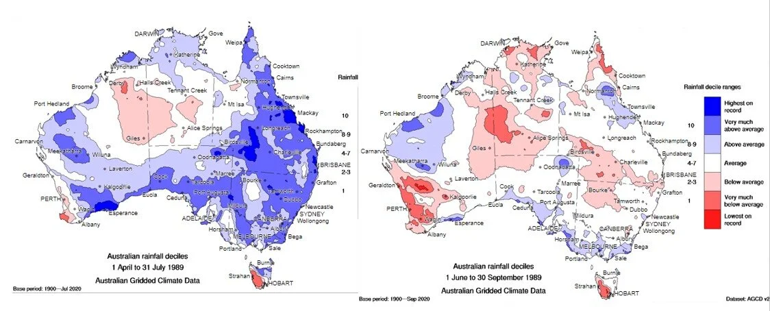
  1. One floated analogue by Accu Weather Climatologist, Jason Nicholls (US) is 1989. A look at this 1989 year shows neutral ENSO, neutral/wet IOD and neutral/wet Modoki index. This is the only year that sticks out since 1980 that ticks these boxes in line with global forecasts. Check your rainfall records for that year for May-October. (1989 rain decile map bottom).

  2. The GCM outputs reviewed last week showed average rainfall and temperatures for the next 3-months. Most models showing decile 4-6 rain, with the exception of the IRI model, which favour decile 7 for NSW. Longer-term IRI prediction favour a wet spring. (top chart with yellow border, below).

The subtle difference between 1989 obs. and the forecast is that in 1989 the Modoki index was in wet phase for winter, then faded to neutral. The outlook in 2021 is for Modoki and possible IOD to strengthen from neutral to wet phases, which is worth keeping an eye on. ENSO looks to be neutral, consistent with 1989/2021.

Jaci Brown’s paper here: https://doi.org/10.1016/j.agrformet.2018.06.001

seasonla bottom.jpg
analogue year.jpg

ARM Online - crop decision support free!

  • Still tossing up between chickpeas or wheat? Looking at spreading your risk with sowing dates and want to know yield ramifications?

  • Run scenarios with various agronomic parameters: sowing density, N application, starting PAWC etc.

  • The real value is changing the climate scenarios using the SOI phase months. Plugging in SOI Positive/neutral will generate different yield outputs.

  • Visit: http://www.armonline.com.au/

The image above shows the CropArm homepage: http://www.armonline.com.au/#/wc

The image above shows the CropArm homepage: http://www.armonline.com.au/#/wc

The top half shows crop choices while the bottom shows a range of outcomes displayed in box and whisker plots.

The top half shows crop choices while the bottom shows a range of outcomes displayed in box and whisker plots.

9-day rainfall outlook

Today’s 9-day ECMWF model loop shows some convective moisture from the warm Ningaloo Reef region in W.A streaming across to NSW through the first week in May. Some rainfall also along the Qld coast. A quick glance at the refreshed IRI and JMA multi-week models and things are looking good with both keen on NSW and sth Qld receiving rain in the next fortnight!! More details on the May outlook next week.

Keep an eye on https://meteologix.com/au for more site-specific analysis.

Image loop courtesy Meteologix

Image loop courtesy Meteologix


Climate in-brief

  • The MJO is showing a strong pulse over Africa in Phases 8 and 1, which historically sees all the moisture pulled westwards away from Australia.

  • The next 3-4 weeks is showing a drier trend, consistent with a fortnight ago, as high air pressure over Australia continues to take up residence.

  • A check on international seasonal model predictions for the May-July period shows no signal for wetter or drier conditions. However, those global models predicting a wet phase Indian Ocean are bullish for spring rainfall looking further out.

  • Very little Tropical Cyclone or activity of any consequence showing for the Australian continent for the remainder of April and the first week of May

The chart above shows higher air pressure over SE Australia in the last 7-days. This anomaly has strengthened in the last week.

The chart above shows higher air pressure over SE Australia in the last 7-days. This anomaly has strengthened in the last week.

Australian daily and weekly rainfall observations

Some spectacular falls in CQ and the rest along the Qld coastline. Click thru to access the maphttp://www.bom.gov.au/australia/flood/?ref=ftr

Some spectacular falls in CQ and the rest along the Qld coastline. Click thru to access the map

http://www.bom.gov.au/australia/flood/?ref=ftr

Weekly rain shows some handy falls across N Qld and N NSW.Australian 7-day rainfall map courtesy http://www.bom.gov.au/climate/maps/rainfall/?variable=rainfall&map=totals&period=week&region=nat&year=2020&month=12&day=17

Weekly rain shows some handy falls across N Qld and N NSW.

Australian 7-day rainfall map courtesy http://www.bom.gov.au/climate/maps/rainfall/?variable=rainfall&map=totals&period=week&region=nat&year=2020&month=12&day=17

Multi-week planner (8-28 days)

Apart from the NSW coast and adjacent ranges, the outlook for much of Queensland and NSW looks drier than normal out to week 3 in May. With a good correlation of the MJO in Phases 4-5 leading to rain this time of year, it will be interesting to see if the current strong pulse of moist air in Phases 8 and 1 progress towards Australia in late May.

Multiweek models.jpg
horse-race-silhouette-3.png

Model commentary: IRI model sitting on the fence and not really excited by anything in the foreseeable future and is still the form equine this calendar year. The JMA got excited by a change at the start of May two weeks ago which has now disappeared and has gone an each-way bet by showing nothing wet or dry through May. The 16-day outlook showing small totals in isolated pockets but nothing much north of 10mm. ACCESS-S is generally in doomsday mode and continues to be further out, but this horse has been struggling to beat the ambulance home. It is also bearish on a favourable IOD development, at odds with other global models.

Go to 10-day Forecast XL for a full summary of all ‘weather models’ as rain events draw closer for your area: https://meteologix.com/au

2021 May-Jul seasonal outlook

A survey of 12 international models condensed in the below charts (top both and bottom LHS) shows optimism for winter rain diminished somewhat compared to a month ago, although a hint of a wet winter from the IRI ensemble. Temperature predictions (bottom RHS) show a similar theme with no signal for cooler or warmer conditions. This is not unusual given most indicators are quite close to neutral. The longer-range charts do favour a wet Indian Ocean Dipole developing and influencing our spring with wetter than normal conditions favoured. More on that next week.

Order of Figures clockwise from top left: ACCESS-S tercile forecast, CS3 multi-model tercile (ECMWF, UK, France, Italy, US, Japan), 5x North American models combined on the bottom showing rainfall (LHS) and temperature (RHS).

seasonla bottom.jpg

Monitoring the MJO this Autumn

The chart below shows a pulse of the MJO strengthening in Phases 8 and 1 out in the Western Indian Ocean. The bottom chart shows the average conditions in those phases historically bringing dry weather. However, phases 4 and 5 look much more encouraging this time of year, so the MJO will be worth keeping an eye on.

The Madden – Julian Oscillation (MJO) is a tropical disturbance that moves eastward around the global tropics every 30-60 days and has proven to influence rainfall and temperature conditions. The strength of the MJO may increase or decrease as it progresses eastwards, affecting the level of convection and influence on both precipitation and temperature. The diagram below is used by scientists to track the path of the MJO showing predicted dates through various phases (see December MJO explainer). A short YouTube cartoon explaining the MJO can be found here

Monitoring soil moisture this winter copping season

A big improvement over the last fortnight in the northeastern half of Queensland and western Darling Downs regions under some rain. The salient feature is still the drying trends in SA and Vic, with more livestock coming on the market as the dry weather starts to bite. The wet phase of the IOD might still be 3 months away for those areas, if it happens.

Rootzone soil moisture 22 April

Water balance.jpg

9-day rainfall outlook

This morning’s 9-day ECMWF model loop shows coastal systems dominating the next period. A check around the grounds on the refreshed seasonal outlook shows a neutral/dry winter and a wetter spring when the IOD/Modoki develops. More detail next week.

Keep an eye on https://meteologix.com/au for more site-specific analysis.

Image loop courtesy Meteologix

Image loop courtesy Meteologix


2021 Long-range driver update

  • The latest global model summary released by the BOM this week shows a neutral ENSO favoured during the business end of the winter crop and spring pasture growing conditions.

  • The Indian Ocean Dipole outlook is again erratic and not settled for 2021 yet. The SST maps are favouring warm water in the east around Java and Indonesia, which may not necessarily be in the eastern IOD box. The last wet event was 2016 and geographically, tends to impact areas from Dubbo south through Vic and SA.

  • The ENSO Modoki is trending neutral/wet (black line, below). The JAMSTEC site and Modoki forecast are currently down, which is unfortunate. Modoki and a potential wet phase of the Indian Ocean could be the story of 2021.

The chart above shows neutral ENSO conditions likelyhttp://www.bom.gov.au/climate/enso/#tabs=Pacific-Ocean

The chart above shows neutral ENSO conditions likely

http://www.bom.gov.au/climate/enso/#tabs=Pacific-Ocean

The BOM’s ACCESS-S model shows this idicator nudging wet thresholds late winter and spring

The BOM’s ACCESS-S model shows this idicator nudging wet thresholds late winter and spring

Indian Ocean Dipole outlook (13 April)

This is very interesting. Along with La Nina Modoki, could well be the story of 2021. Watered down a bit from a month ago.  Forecasts this far out need to be taken with a pinch of salt, however, no need for alarm bells for a repeat of 2019 when we h…

This is very interesting. Along with La Nina Modoki, could well be the story of 2021. Watered down a bit from a month ago. Forecasts this far out need to be taken with a pinch of salt, however, no need for alarm bells for a repeat of 2019 when we had a strong dry phase.

Forecast chart courtesy:http://www.bom.gov.au/climate/enso/#tabs=Indian-Ocean

Meet the researcher - Dr Lisa Goddard

Lisa pic short hair 1.jpg

Dr Lisa Goddard

Climate researcher

Farmer Forecast relies heavily on multi-week, ENSO and seasonal forecasts from the International Research Institute (IRI) at Columbia University in the United States. This week, we chat with Dr. Lisa Goddard, the Director and Senior Research Scientist of the IRI. Lisa oversees research and product development aimed at providing climate information at the 10-20 year horizon and how that low-frequency variability and change interacts with the probabilistic risks and benefits of seasonal-to-interannual variability. Most of Lisa’s research focuses on diagnosing and extracting meaningful information from climate models and available observations. Lisa holds a Ph.D. in atmospheric and oceanic sciences from Princeton University and a B.A. in physics from the University of California at Berkeley.

Farmer Forecast caught up with Lisa to hear how a career in climate science evolved, along with seeking insights into seasonal forecasting more generally and which ENSO phase might be on the horizon in 2021.

What inspired you to become a climate researcher and at what age was this?
I decided to go into climate research when I was considering graduate school after getting my BA degree in physics. I loved physics, but did not really want to pursue the theoretical path. At that time, in the late 1980s, there was just starting to be stories in the news about the ozone hole and global warming. I thought, “This is an exciting way to apply my physics knowledge. This is something I want to learn more about, and maybe help people.”

Do you have any extended family or other connections with farming or agriculture, as much of your work involves helping farmers adapt to climate extremes?
No. My mother was a special education teacher, and my father worked for the State of California.

What are your favourite activities or interests away from research that helps recharge you for work mode?
My family and my dog, Chewy, are the most important source of joy in my life outside of work. I also enjoy hiking, reading, and gardening. I guess I do have a little connection to agriculture, but that’s fairly new.

Pacific Decadal Oscillation (PDO) is also a keen area of your research interests. This is also something that can offer farm managers some guidance for big-picture decision making. The rainfall charts produced by the longpaddock.com.au are fascinating, with clearly defined wet and dry phases that seem broadly aligned with the PDO. It seems more obvious in hindsight, but what are the issues with predicting the next move of decadal oscillation?
The Interdecadal Pacific Oscillation is a climate pattern in the Pacific that varies from decade to decade and affects global and regional climate on 10–40 year timescales. It is like El Niño and La Niña’s older, slower-moving, uncle or auntie, I suppose. We have lots of clues as to what drives these slow changes, and how they link to other ocean basins and the El Niño system, as well as how this pattern has behaved in the past, including the impacts on Australia. But our understanding of the underlying physics and potential avenues for predictability of these decade to decade changes remains a matter for ongoing research.

Lisa presenting.jpg
Columbia University is a diverse, academic community of more than 40,000 students, faculty, and staff from across the nation and the world, living and learning on dynamic campuses.

Columbia University is a diverse, academic community of more than 40,000 students, faculty, and staff from across the nation and the world, living and learning on dynamic campuses.

 
Lisa with former Secretary of State Hillary Clinton.

Lisa with former Secretary of State Hillary Clinton.

Australian Farmers follow IRI ENSO predictions, seasonal and sub-seasonal forecasting regularly, as chart presentation in terciles is easy to understand. In your experience, what is one of the biggest challenges for users interpreting forecasts to translate into risk management and action?

I have seen that most decision-makers have a tough time using terciles. Part of the difficulty is that they may not know what constitutes above-normal or below-normal. Farmers are usually much more attuned to these things than the rest of the public. In addition to this categorical representation of the upcoming climate, terciles may not be the right decision point for all sectors. For example, in Southern Africa, the malaria community is interested in the wettest/driest 25% of the historical distribution. Disaster risk reduction efforts in the humanitarian sector are often more concerned with extremes. For this reason, the IRI started issuing what we call Flexible Format Forecasts about 10 years ago. In this way, someone coming into the forecast map rooms can ask to see the probability of being in say the driest 20% of the historical record or the probability of exceeding 10 cm in the coming season. This takes the decision away from the producer of the forecast and gives it back to those actually using the information.

In the most recent year with the late arrival of La Niña, GCMs tended to be over bullish on precipitation forecasts. Those predictions have certainly created scepticism about GCM outputs when rain hasn’t eventuated. How important is it to sense-check GCM outputs with climate fundamentals, such as SSTs distribution, statistics and other known research outputs for users to better manage risk?
This is the chronic frustration inherent in probabilistic information. The GCMs and the range of possibilities they produce are based on the response to current ocean, land, and atmosphere conditions. Models are not perfect, but they can be calibrated – both in strength and range of responses. It is important that this is considered and folded back into the forecasts. This is how IRI approach its seasonal forecasts. Even with all the care possible, though, nature may still deal the unexpected, low-probability outcome. If we had perfect models, Nature would be only one of many, many ensemble members, after all. One cannot easily get over feeling ‘burned’ by a forecast that seems wrong, but I would encourage users of forecasts to take a look at the longer-term performance of those forecast systems – like 10-20 years or more, before condemning them to the waste heap.

What do you see are the biggest challenges for climate scientists in the coming decade in terms of boosting seasonal model accuracy in a changing climate?
I think the challenge for seasonal forecasts will be to better capture the extremes, and extreme seasonal behaviour, of the climate system. Due to the changing climate and increased public awareness, there is a tendency to attribute all extreme events to climate change. Seasonal forecasts must include the drivers of climate change as well (most of them do), not because the greenhouse gasses change enough to make a difference from one season to the next, but their evolution will affect the trends in the model history, which is important for context. So, more accurate forecasts of extreme weather characteristics and seasonal means/totals a season or two ahead should provide considerable value for communication as well as for considerations of adaptive management.

The current ENSO forecasts are showing neutral-ish conditions for the second half of the year, although we are in the known predictability ‘gap’ at the moment. What do you think the chances of a La Niña forming are, as history shows quite of often one La Niña event will follow another?
According to some analysis done by one of my colleagues, about half of the La Niñas (not preceded by a La Niña) are followed by a second La Niña. We would typically look to the ocean for information on that possibility. The most robust condition for that is if the upper ocean heat content does not recover to normal or greater in the demise of the event. Currently, that is not the case; the heat content is almost back to normal. Other recent research has pointed to signals from the decaying La Niña reflecting off the coast of South America and influencing the air-sea coupling in the second half of the year. There are no obvious signals in the tropical Pacific right now. There are a few models that keep re-developing La Niña later this year, but the most bullish of those has been pathologically extreme throughout this event, another couple is related in their genealogy and also use the same analysis for their initial conditions. The spread of the models is just really all over the place. I think we need to wait a couple of months for more clarity.

 
A shot of Lisa as a calendar ‘çlimate model’ in standing at the edge of the Pulcaro Reservoir in Chile.

A shot of Lisa as a calendar ‘çlimate model’ in standing at the edge of the Pulcaro Reservoir in Chile.


This is the April run of the IRI’s seasonal outlook (fresh off the press this morning) for the business end of the winter crop 2021.

This is the April run of the IRI’s seasonal outlook (fresh off the press this morning) for the business end of the winter crop 2021.


Any questions, feedback for Lisa or Farmer Forecast?

Email us at: farmerforecast@agecon.com.au