

Climate in-brief
/After a fairly busy 4 weeks, the climate is settling into more or a benign state for much of northern and eastern Australia, as we wait for tropical moisture to arrive from an active monsoon in the Indian Ocean.
Very little in the way of cyclone activity expected in the coming fortnight, as waters cool slightly to Australia’s north
The Southern Annular Mode is predicted to retreat into negative values, before recovering into more neutral or slightly positive numbers and not impact our climate.
Multi-week models showing little excitement in terms of rainfall for areas other than FN Qld and the northern tropics. Other than patchy storm rain, vast areas of NSW and Qld may experience cooler and drier conditions out to week 2 February.
The MJO is difficult to track at present. The latest NCEP report states “stationary La Niña signal continuing to dominate the overall global tropical convective field”.

The chart above shows higher-than-normal air pressure over Southern Australia for the last 7-days and lower air pressure to the NW.
Australian daily and weekly rainfall observations
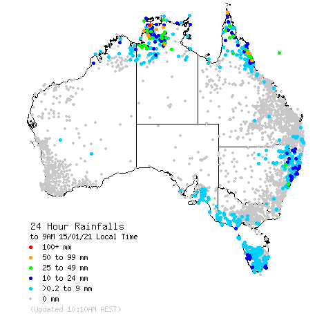
Some patchy falls confined to the NSW, Qld and NT coast and ranges in the last day or so. Click on the link for an updated map. http://www.bom.gov.au/australia/flood/?ref=ftr

Weekly rain shows some fantastic falls across the tropics and parts of CQ desperately in need of rain. NSW has been on the skinnier end of falls in the last week.
Australian 7-day rainfall map courtesy http://www.bom.gov.au/climate/maps/rainfall/?variable=rainfall&map=totals&period=week®ion=nat&year=2020&month=12&day=17