Monitoring the MJO this Autumn

The chart below shows a moderate pulse of the MJO in Phase 2/3 over the Indian Ocean (end black line). Models are anticipating the MJO to make its way east into Phases 5-6 (red and blue lines) into the region north of Australia through the first week of April. This is the one of the first few discernible MJO events we’ve seen this wet season. Nothing much in terms of rainfall showing up on the models yet, but it could develop in weeks 2-3 in April after the MJO passes.

The Madden – Julian Oscillation (MJO) is a tropical disturbance that moves eastward around the global tropics every 30-60 days and has proven to influence rainfall and temperature conditions. The strength of the MJO may increase or decrease as it progresses eastwards, affecting the level of convection and influence on both precipitation and temperature. The diagram below is used by scientists to track the path of the MJO showing predicted dates through various phases (see December MJO explainer). A short YouTube cartoon explaining the MJO can be found here

Tracking atmospheric water vapour (Sun - Wed)

This is pretty rare. Water vapour levels are in the extreme range basically all week. The image below shows a concentration of water vapour over central-eastern Australia for the period Sunday through Wednesday.

The water vapor content of the atmosphere is of critical importance to nearly every facet of atmospheric science. Observing the processes that determine the water vapor content of the atmosphere is, therefore, of fundamental importance. As the earth’s surface is the source of most atmospheric water vapor, observations of vertical turbulent transport of water vapor in the planetary boundary layer have been the subject of many research projects. Evapotranspiration can vary significantly across the earth’s surface due, for example, to variability in insolation, vegetation cover, soil properties, and precipitation. Area-averaged water vapor flux measurements are necessary to get a large-scale view of surface–atmosphere interactions. 

The Extreme Forecasting Index (EFI) is an integral measure of the difference between the ensemble forecast (ENS) distribution and the model climate (M-climate) distribution. This allows the abnormality of the forecast weather situation to be assessed without defining specific (space- and time-dependant) thresholds. The EFI takes values from -1 to +1. If all the ensemble members forecast values above the M-climate maximum, EFI = +1; if they all forecast values below the M-climate minimum, EFI = -1. Experience suggests that EFI magnitudes of 0.5 - 0.8 (irrespective of sign) can be generally regarded as signifying that "unusual" weather is likely whilst magnitudes above 0.8 usually signify that "very unusual" weather is likely. Although larger EFI values indicate that an extreme event is more likely, the values do not represent probabilities as such. 

9-15 day rainfall outlook

Two leading models this week: 9-day ECMWF and NCEP 15-day loop.

Some serious rainfall activity predicted for parts of Australia’s NW and eastern areas.

A sneak peek at the updated multi-week models just now shows the BOM model going extreme wet ‘till mid-April, JMA showing slightly above average and the IRI model much more cautious with a focus on rain events for inland NSW, Qld channel country and the Gulf for the next 3 weeks.

Updated SSTs show waters warming to Australia’s north and the Coral Sea continues to warm up, which is encouraging.

Keep an eye on https://meteologix.com/au for more site-specific analysis.

Image loop courtesy Meteologix

Image loop courtesy Meteologix

modusa_20210318_2200_animation 15day.gif

Monitoring the MJO this Autumn

The chart below shows a weak pulse of the MJO in Phase 1 over Africa. Models are anticipating the MJO to run out of steam and go back into its shell. It is essentially buried among the broad-scale La Nina pattern still at play, making it difficult to track. Nothing much to see here.

The Madden – Julian Oscillation (MJO) is a tropical disturbance that moves eastward around the global tropics every 30-60 days and has proven to influence rainfall and temperature conditions. The strength of the MJO may increase or decrease as it progresses eastwards, affecting the level of convection and influence on both precipitation and temperature. The diagram below is used by scientists to track the path of the MJO showing predicted dates through various phases (see December MJO explainer). A short YouTube cartoon explaining the MJO can be found here

Tracking atmospheric water vapour (Sat-Sun)

The prediction for extreme water vapour levels shows a concentration over the mid-latitudes over the weekend, where moisture is streaming across from NW Australia.

The water vapor content of the atmosphere is of critical importance to nearly every facet of atmospheric science. Observing the processes that determine the water vapor content of the atmosphere is, therefore, of fundamental importance. As the earth’s surface is the source of most atmospheric water vapor, observations of vertical turbulent transport of water vapor in the planetary boundary layer have been the subject of many research projects. Evapotranspiration can vary significantly across the earth’s surface due, for example, to variability in insolation, vegetation cover, soil properties, and precipitation. Area-averaged water vapor flux measurements are necessary to get a large-scale view of surface–atmosphere interactions. 

The Extreme Forecasting Index (EFI) is an integral measure of the difference between the ensemble forecast (ENS) distribution and the model climate (M-climate) distribution. This allows the abnormality of the forecast weather situation to be assessed without defining specific (space- and time-dependant) thresholds. The EFI takes values from -1 to +1. If all the ensemble members forecast values above the M-climate maximum, EFI = +1; if they all forecast values below the M-climate minimum, EFI = -1. Experience suggests that EFI magnitudes of 0.5 - 0.8 (irrespective of sign) can be generally regarded as signifying that "unusual" weather is likely whilst magnitudes above 0.8 usually signify that "very unusual" weather is likely. Although larger EFI values indicate that an extreme event is more likely, the values do not represent probabilities as such. 

9-15 day rainfall outlook

Two leading models this week: 9-day ECMWF and NCEP 15-day loop.

Some serious activity predicted for parts of Qld previously missing out, as well as eastern NSW.

Moisture from Australia’s north-west seems to be joining up with moist air in the Coral Sea and where exactly it lands will be interesting.

A game-changing event for those who’ve been on the skinny end of a pop-gun La Nina so far this summer.

Keep an eye on https://meteologix.com/au for more site-specific analysis.

Image loop courtesy Meteologix

Image loop courtesy Meteologix

modusa_20210311_2300_animation GFS.gif

9-day ECMWF rainfall outlook

The European ECMWF weather model shows some serious rainfall activity through central-eastern Australia during the next 9-day period, as the Coral Sea finally warms up. The US NCEP model is even more bullish for bigger +100mm totals. A sneak peek at the refreshed multi-week models this morning shows NSW in the sweet spot for the remainder of March, with NW tropical moisture streaming down across the desert. More analysis next Friday.

Access courtesy https://meteologix.com/au

Image loop courtesy Meteologix

Image loop courtesy Meteologix


Monitoring the MJO this summer

The chart below shows a weak pulse of the MJO active in Phase 5 in the Coral Sea region. Models are anticipating the MJO to run out of steam and go back into its shell. It is essentially buried among the broad-scale La Nina pattern still at play, making it difficult to track.

The Madden – Julian Oscillation (MJO) is a tropical disturbance that moves eastward around the global tropics every 30-60 days and has proven to influence rainfall and temperature conditions. The strength of the MJO may increase or decrease as it progresses eastwards, affecting the level of convection and influence on both precipitation and temperature. The diagram below is used by scientists to track the path of the MJO showing predicted dates through various phases (see December MJO explainer). A short YouTube cartoon explaining the MJO can be found here

9-day ECMWF rainfall outlook

The European ECMWF 9-day model shows rainfall activity creeping inland off the east coast and persisting through inland FN Qld. A positive SAM is pushing moisture into NSW and a sub-tropical low is developing in the Tasman Sea also.

Looking beyond the 9-day period, the northern half of Australia appears to be going toward a drier period, before more low pressure and cloud activity returns at the end of the 1st week in March.

Tune in next week for a full analysis.

Access courtesy https://meteologix.com/au

Image loop courtesy Meteologix

Image loop courtesy Meteologix


Monitoring the MJO this summer

Much of our moisture originates from the tropics this time of year. The chart below shows the MJO active in Phase 7 out in the Western Pacific Ocean. Models are anticipating the MJO to run out of steam and go back into its shell for the remainder of February and have little or no influence on our climate.

The Madden – Julian Oscillation (MJO) is a tropical disturbance that moves eastward around the global tropics every 30-60 days and has proven to influence rainfall and temperature conditions. The strength of the MJO may increase or decrease as it progresses eastwards, affecting the level of convection and influence on both precipitation and temperature. The diagram below is used by scientists to track the path of the MJO showing predicted dates through various phases (see December MJO explainer). A short YouTube cartoon explaining the MJO can be found here

9-day ECMWF rainfall outlook

The European ECMWF 9-day model shows a kaleidoscope of colour, with rainfall predicted through northern and eastern Australia in the coming week and a half. A positive SAM is pushing moisture into NSW and rain is also showing in the desert channels and other regions through the interior. However, models are divided, so its there is real value in checking the Meteologix model survey to see how the predicted amounts differ, to better evaluate your chances of rain through this period. Access courtesy https://meteologix.com/au

Image loop courtesy Meteologix

Image loop courtesy Meteologix


9-day ECMWF rainfall outlook

The European ECMWF 9-day model shows good falls in the SE as well as inland tropical areas at lower latitudes. A quick peek at the refreshed multi-week models this morning shows non-consensus for the remainder of February, with the JMA calling for wet conditions continuing, while the BOM and IRI (US) are sitting on the fence for neither wet nor dry. Probably safe to assume storms will be around and temperatures will continue to be milder than normal. Access courtesy https://meteologix.com/au

Image loop courtesy Meteologix

Image loop courtesy Meteologix


Monitoring the MJO this summer

Much of our moisture originates from the tropics this time of year. The chart below shows the MJO breaking out of the circle (to active phase) into Phase 6 out in the Western Pacific Ocean. Most of the action appears to now be centred around these longitudes, to the east of Australia “ Enhanced convection is favoured to increase over the western Pacific to the west of the Date Line during the next two weeks” NCEP report 25 Jan 2021. This is not ideal for those of us looking for rain, as we may have to wait for the MJO to return on later in February to see some genuine monsoon activity on a decent scale.

The Madden – Julian Oscillation (MJO) is a tropical disturbance that moves eastward around the global tropics every 30-60 days and has proven to influence rainfall and temperature conditions. The strength of the MJO may increase or decrease as it progresses eastwards, affecting the level of convection and influence on both precipitation and temperature. The diagram below is used by scientists to track the path of the MJO showing predicted dates through various phases (see December MJO explainer). A short YouTube cartoon explaining the MJO can be found here

9-day ECMWF rainfall outlook

The European ECMWF 9-day model shows good falls in the SE as well as the same tropical areas that are already quite wet. NCEP is more conservative, although the BOMs 8-day WATL model is more encouraging. Once we are through the 1st week of Feb, then opportunities for rain look reasonably thin, so caution required.

Access courtesy https://meteologix.com/au

modez_20210128_2300_animation.gif

Tracking atmospheric water vapour (Sat-Tue)

The prediction for water vapour levels shows a concentration over north-west Australia, and surprisingly not showing up (as high levels) over SE Australia where rain is predicted for Monday-Tuesday.

The water vapor content of the atmosphere is of critical importance to nearly every facet of atmospheric science. Observing the processes that determine the water vapor content of the atmosphere is, therefore, of fundamental importance. As the earth’s surface is the source of most atmospheric water vapor, observations of vertical turbulent transport of water vapor in the planetary boundary layer have been the subject of many research projects. Evapotranspiration can vary significantly across the earth’s surface due, for example, to variability in insolation, vegetation cover, soil properties, and precipitation. Area-averaged water vapor flux measurements are necessary to get a large-scale view of surface–atmosphere interactions. 

The Extreme Forecasting Index (EFI) is an integral measure of the difference between the ensemble forecast (ENS) distribution and the model climate (M-climate) distribution. This allows the abnormality of the forecast weather situation to be assessed without defining specific (space- and time-dependant) thresholds. The EFI takes values from -1 to +1. If all the ensemble members forecast values above the M-climate maximum, EFI = +1; if they all forecast values below the M-climate minimum, EFI = -1. Experience suggests that EFI magnitudes of 0.5 - 0.8 (irrespective of sign) can be generally regarded as signifying that "unusual" weather is likely whilst magnitudes above 0.8 usually signify that "very unusual" weather is likely. Although larger EFI values indicate that an extreme event is more likely, the values do not represent probabilities as such. 

9-day ECMWF rainfall outlook

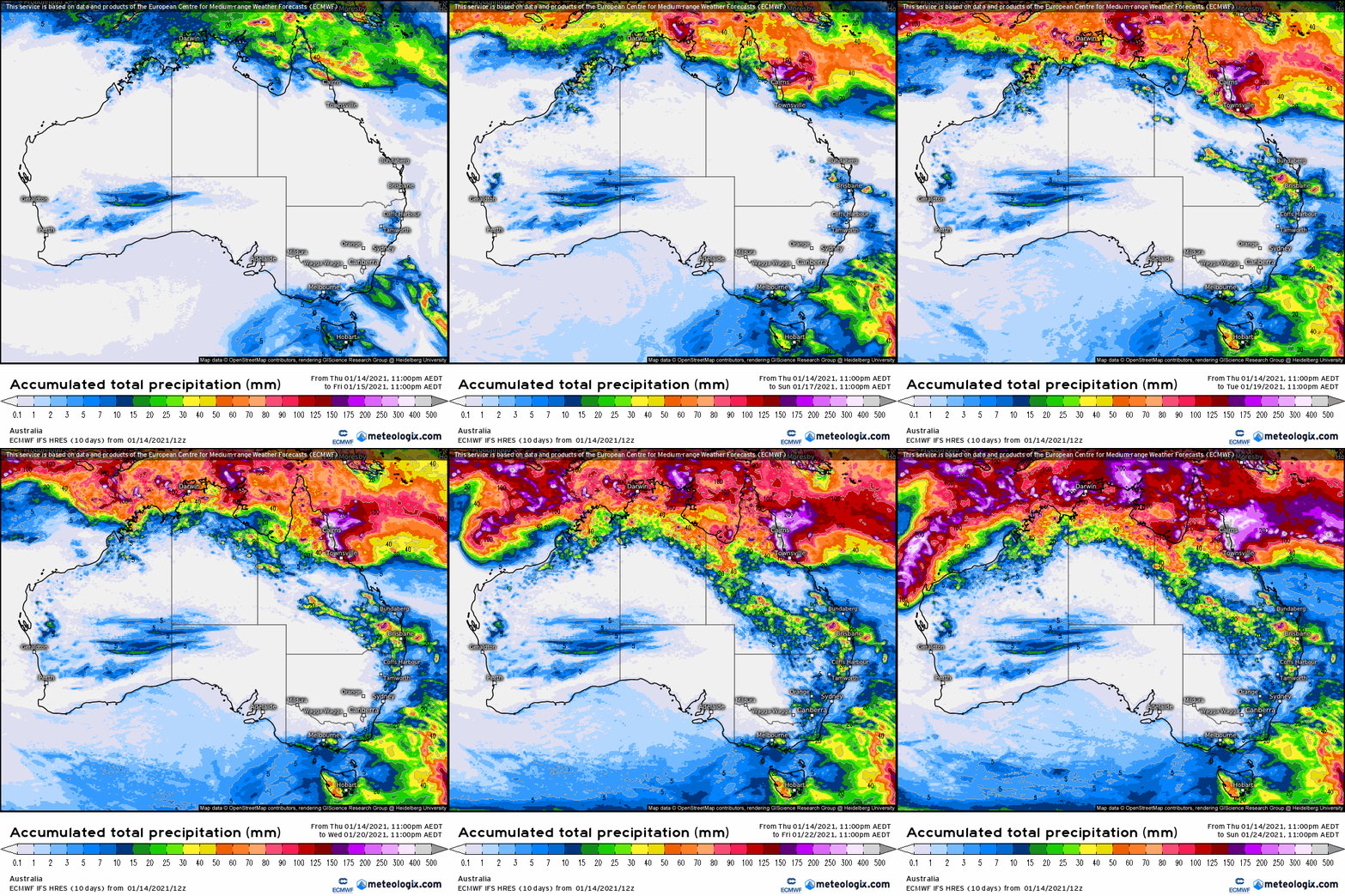
The European ECMWF 9-day model shows spectacular colours and rainfall for the NT Big Rivers and Kununurra between now and 31 Jan. The Murray Darling Basin looks to miss out, but a peek at the updated multi-week models shows something more general could be on for 2nd week in February, as the MJO strengthens into Phase 6. More details next Friday, as we have a closer look.

Access courtesy https://meteologix.com/au

modez_20210121_2100_animation.gif

Monitoring the MJO this summer

Much of our moisture originates from the tropics this time of year. The chart below shows the MJO currently in Phase 3 out in the Indian Ocean. A weak pulse may affect Australia (Phases 5-6) at the end of January. rather than the MJO, the latest NCEP report states “stationary La Niña signal continuing to dominate the overall global tropical convective field”

The Madden – Julian Oscillation (MJO) is a tropical disturbance that moves eastward around the global tropics every 30-60 days and has proven to influence rainfall and temperature conditions. The strength of the MJO may increase or decrease as it progresses eastwards, affecting the level of convection and influence on both precipitation and temperature. The diagram below is used by scientists to track the path of the MJO showing predicted dates through various phases (see last weeks edition for MJO explainer). This illustrates the MJO currently inactive inside the circle, then increasing in strength through week 2 in January as it reaches the maritime continent. Not all models are aligned and some show no signal for the MJO whatsoever. A short YouTube cartoon explaining the MJO can be found here